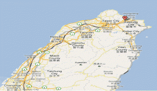
Keelung
 |
 |
Before the city was founded by the Spanish Empire in 1626, then called La Santisima Trinidad, present-day Keelung was inhabited by Taiwanese indigenous peoples and was part of Spanish and Dutch colonial rule before being subsumed into the Qing dynasty in 1683 as part of Fujian. The city became a flashpoint of the First Opium War and the Keelung Campaign in the Sino-French War. Taiwan was detached from Fujian in 1887 and Keelung became part of the Empire of Japan in 1895 following the First Sino-Japanese War. During the Japanese era, the city was known as Kirun first as a town of Taihoku Prefecture, then became a district in 1920 and finally a city in 1924. After World War II in 1945, the Republic of China, which deposed the Qing several years before, reestablished Keelung as a provincial city of Taiwan Province, which would later became streamlined from 1998.
Nicknamed the Rainy Port for its frequent rain and maritime role, the city is Taiwan's second largest seaport (after Kaohsiung) and the 7th largest in the world.
According to early Chinese accounts, this northern coastal area was originally called Pak-kang. By the early 20th century, the city was known to the Western world as Kelung, as well as the variants Kiloung, Kilang and Keelung. In his 1903 general history of Taiwan, US Consul to Formosa (1898–1904) James W. Davidson related that "Kelung" was among the few well-known names, thus warranting no alternate Japanese romanization.
However, the Taiwanese people have long called the city Kelang. While it has been proposed that this name was derived from the local mountain that took the shape of a rooster cage, it is more likely that the name was derived from the first inhabitants of the region, as are the names of many other Taiwanese cities. In this case, the Ketagalan people were the first inhabitants, and early Han settlers probably approximated "Ketagalan" with Ke-lâng (Ketagalan: ke-, "domain marker prefix" + Taiwanese Hokkien ), the noun root being replaced with the common Taiwanese Hokkien term for people, while the domain marker circumfix "ke- -an" being reduced to just the prefix.
In 1875, during the late Qing era, a new official name was given. In Mandarin, probably the working language of Chinese government at the time, both the old and new names were likely pronounced Gīlóng (hence "Keelung").
Under Japanese rule (1895–1945), the city was also known to the west by the Japanese romanization Kīrun (also written as Kiirun ).
In Taiwanese Hokkien, native language of the area, the city is called Ke-lâng. In Hanyu Pinyin, a system created for Mandarin Chinese in Mainland China, the name of Keelung is written as Jīlóng (the shift from initial K to J is a recent development in the Beijing dialect, see Old Mandarin).
Map - Keelung
Map


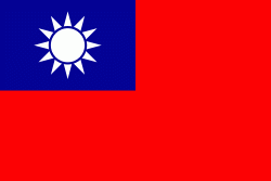
Country - Taiwan
 |
 |
| Flag of Taiwan | |
* in East Asia. It is located at the junction of the East and South China Seas in the northwestern Pacific Ocean, with the People's Republic of China (PRC) to the northwest, Japan to the northeast, and the Philippines to the south. The territories controlled by the ROC consist of 168 islands, with a combined area of 36193 km2. The main island of Taiwan, also known as Formosa, has an area of 35,808 km2, with mountain ranges dominating the eastern two-thirds and plains in the western third, where its highly urbanised population is concentrated. The capital, Taipei, forms along with New Taipei City and Keelung the largest metropolitan area of Taiwan. Other major cities include Taoyuan, Taichung, Tainan, and Kaohsiung. With around 23.9 million inhabitants, Taiwan is among the most densely populated countries in the world.
Currency / Language
| ISO | Currency | Symbol | Significant figures |
|---|---|---|---|
| TWD | New Taiwan dollar | $ | 2 |
| ISO | Language |
|---|---|
| ZH | Chinese language |